Showing posts with label Cagayan de Oro River. Show all posts

Saturday, June 3, 2023

Cagayan de Oro River Boulevard

A major component of flood risk management project for Cagayan de Oro River which is called river boulevard is now completed. The local government of Cagayan de Oro has now allowed people to enter the newly finished infrastructure although it is still off limits to vehicles. The project is funded by loan from Japan International Cooperation Agency (JICA) through the Official Development Assistance (ODA) under the foreign ministry of Japan.     

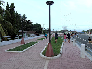
The features of the finished project consist of a 2.3 kilometers two-lane concrete road that covers the distance from J.R Borja to Kauswagan Bridges or vice versa and traversing the Marcos Bridge in between. At the eastern side of the road is a walkway with railings on both sides. And at the western side of the road facing the river bank is a promenade with adobe-like floorings and lamp posts, and along its course are lines of rectangular shaped garden plots with grasses which may also be planted with decorative plants or trees in the future. On the edge of the promenade facing the river is short concrete fence or wall with steel railings on top. That  wall is actually the upper portion of the flood wall that runs the entire length of the boulevard.

For now, people visit the boulevard for strolling, jogging, biking, exercising or taking pictures or video. The best time to visit the boulevard during a good weather for said purposes is in the early morning or in the late afternoon when the heat of the sun is no longer too hot or harsh to the skin or even in the evening since the boulevard is illuminated with street lights.

With the way it attracts people, the boulevard can become one of the tourist destinations of the city. And when opened for the vehicles, its two-lane road can somehow help ease decongest the traffic in the city's downtown area.


Friday, June 2, 2017

Cagayan River, CDO's Natural Identifying Terrain Feature


Most of the major cities of the world are located at the banks of rivers and history has it that earliest civilizations evolved and developed in river valleys. Examples are the Nile River of Egypt, the Tigris and Euphrates Rivers of the Fertile Crescent, the Ganges River of India and the Yangtze River of China. Ancient people converged to the river because of the water which is essential for life. The area around the river creates an ecosystem conducive for humans and animals to live dependently with each other. In addition, the overflow of river carries with it sediments along the banks which makes the soil in that area fertile for planting food crops. However, river can be destructive during events such as typhoons and heavy rains that cause its channel to overflow and flood the outlying areas near its banks.


In northern Mindanao, in ancient times, indigenous nomadic people followed the course of the river called Kalambaguasahan to search for games, fish and other foods. Finding caverns on a promontory, they made it as their shelter and over time made a settlement around that area which was 8 Kilometers south from the center of the present day Cagayan de Oro. That place was conducive for their survival since the river provided them source of food and water, and the promontory with its elevated location afforded them security from other hostile tribes. As the settlement called Himologan grew, interactions and trade with other places developed. Its outside contacts even reached as far as Butuan and Maguindanao. Sultan Kudarat, the Muslim chieftain of Maguindanao later imposed a tribute to the settlement of Himolugan.   


The payment of tribute should be overemphasized because it was a sort of jizya which is a tax levied by a Muslim ruler over his non-Muslim subjects in exchange of his protection to them. The tribute to the Muslim ruler also carried with it the implications that they recognized his authority, that his followers would not attack or harass them, and that they would not be obliged to convert to Islam. That practice is probably the reason why the early inhabitants of the city were polytheistic animists and not Muslims despite the fact that the sultan’s sphere of influence had reached that small settlement.

 
In 1622, the Spaniards arrived and came upon the old settlement which was also called “Cagayan” which is an Austronesian word for river. Fray Agustin de San Pedro then successfully convinced the inhabitants led by Datu Salangsang to move to a new settlement located in an area of what is now the Gaston Park and Saint Augustine Cathedral. In the new Cagayan the priest converted the natives to Christianity and told them to stop paying tributes to the Muslim Sultan. With a more powerful new protector, the Spaniards, the natives were able to avoid possible retribution from the Muslims for stopping the payment of tribute and embracing Christianity.. 

Myths and legends abound in relation to this great river. There is a story of a giant fish that supposedly devoured a priest from the Saint Augustine Cathedral. That tale was probably a misinterpretation of a tablet on a fence wall which was long removed from public view which depicted the Biblical story of Jonah and the whale. Superstitious people also believe that the river is inhabited by supernatural creatures such as aquatic monster that drowns their victim to death by grabbing his feet as he unsuspectingly swims in the river.

The river is one of the venue on which the city government promotes tourism. Upstream is a good place for whitewater rafting which is popular to tourists. Kayaking and river trekking are also tourist promoting activities. At present, there are 6 bridges that span the eastern and western banks of the river which also serves as a boundary between the 1st and the 2nd districts of the city.


Despite its scenic beauty and fantastic tales, Cagayan River at times can be a bearer of death and destruction. There were some incidents in the past on which the swelling of the river channel caused flooding that resulted to loss of lives and properties. On December 16-17, December 2011, Typhoon Sendong hit Northern Mindanao. The huge volume of rainwater falling on the mountain ranges of Bukidnon sent massive volume of waters, mud, sediments, logs and rocks downstream in an overwhelming force that swept away people, houses and animals along the way resulting to thousands of deaths. That tragedy which claimed the lives of 1,268 people was the biggest natural disaster that the city experienced in decades. 

The river is vulnerable to degradation due to people’s activities such as illegal mining, logging, quarrying and the irresponsible disposable of waste products by people living along the river banks. Those bad practices cause bank soil erosion, shallow river bed, pollution of the water and the overflow of river during heavy rains which flood the nearby areas. To preserve the river, the city government adopted measures to stop people from doing activities that will adversely affect the river and its nearby environment. City residents also voluntarily plant trees along the river banks and mangroves at the mouth of the river. 


From its sources in Kalatungan and Kitanglad mountain ranges in Bukidnon, the waters of Cagayan River run through a 90 kilometers course that traverses the municipalies of Libona, Talakag and Baungon in Bukidnon and Cagayan de Oro where they finally empty into Macajalar Bay.

Cagayan River and the Malasag mountain range are two of the most prominent terrain features that can be seen at the heart of the city. The river is associated with the city’s name, history and cultural development. “Cagayan”, a name taken from an old settlement aptly describes CDO’s location which is a city by the river.


Friday, February 10, 2017

Macahambus Cave and Gorge


Macahambus Cave and Macahambus Gorge are some of the natural tourist attractions of Cagayan de Oro City which are located south of Lumbia Airport which is now a Philippine Air Force base. The natural cave is located at the eastern side of a highway going to Bukidnon.  At the mouth of the cave are two markers from the National Historical Institute. Inside the cave is the main chamber which can accommodate 10 to 20 standing people. It is totally dark inside and the atmosphere is eerie so that a visitor needs a flashlight to illuminate his surroundings. There is no large amount of stalagmites or stalactites in the cave but traces of them are visible. Some fruit bats hang on the ceiling and walls of the cave. Moving farther, a visitor can make out a short tunnel that is faintly illuminated by a natural light. To get out through the other end of the cave, he has to follow the light. Since the space in the tunnel is narrow, he has to crouch his way out of the cave. Right outside the cave’s exit is a viewing deck or veranda which without it a careless visitor will fall off a steep precipice with boulders beneath it. On the viewing deck he sees the scenic Cagayan de Oro River. He can get back to the highway without entering back the cave by walking through the short bridge that leads to a footpath on a slope.


Cagayan de Oro River from the viewing deck
An exit path with railings
Just about 200 meters from the entrance of Macahambus Cave at the western side of the road is the Macahambus Gorge or doline. Looking at the gorge from a high ground, the visitor sees it as just an ordinary terrain with cliffs, high ground and low ground with lush vegetation. The physical shape of the gorge or the doline is made indistinguishable by the trees, vines and bushes that cover the surface of the ground. A visitor
has to climb down the flight of steps of a steel staircase to explore the bottom of the gorge. 

                  
The bottom of the gorge

Aside from being tourist attraction, the Macahambus Cave and Macahambus Gorge are also natural historical monument of the city because the hills at these cave and gorge are the site of the battle between the US and Filipino forces during the Philippine-American War in the last year of the 19th century. The “Battle of Macahambus Hill” is one of the few battles where the Filipino combatants prevailed over the better armed and trained American soldiers.

American troops in the area of Macahambus Hills in 1900


Monday, August 27, 2012

Kagay-an Festival 2012 (Cagayan de Oro Fiesta)

Click picture to view an enlarged image or a slide show
In honor of Saint Augustine, Cagayan de Oro City celebrates its Kagay-an Festival 2012 or its fiesta on August 28, 2012. Unlike last year when the activities were administered by the City government in partnership with Promote CDO Foundation Inc., a private organization, this year’s activities are being undertaken solely by the city government. The pattern of celebration is very much similar to the fiestas that were held in the past. It involves the holding of different core events that culminates in the day of the festivity on August 28.  


The celebration of the fiesta is a manifestation that the city has gotten over the devastation caused by the ravages of Typhoon Sendong which claimed thousands of lives and resulted to the loss of millions of pesos in properties in December last year.


Miss Kagay-an 2012
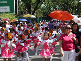
This year’s Kagay-an Festival started with a marathon on the morning of August 19, 2012 from the Rodelsa Circle to the streets of the City. On August 25, the P.E. Rhythmic Festival was held at the Pelaez Sports Center Complex (PSCC). It was participated by students of the city’s schools. On August 26, 2011 there was the Cultural Street Dancing competition on which different representative groups started at the Rodelsa Circle and moved along the city’s thoroughfares. The colorful native costumes worn by the participants added liveliness to their show as they entertained people as they marched and danced in the streets. One of the most interesting events of the festival was the Miss Kagay-an 2012 Coronation Night which was held at Lim Ket Kai Atrium on the evening of August 26, 2012. The program was led by no other than Vicente Emano, the mayor. He was assisted by the different committees led by local city officials as well as private groups or persons who are sponsors of that particular event. Greanne Trisha T. Mendoza was crowned as the Miss Kagay-an 2012. On August 27, 2011 there was the Civic-Military and Float Parade in the main streets of the city. Participants of the parade included NGOs, military and police units and industrial and commercial entities. On the same day in the evening there was a Pyro Festival where participating groups display their fireworks in view of many people outside the Shoe Mart Mall.


Other activities that were held included the Agro Fair in which different agricultural products from the barangays of the city are displayed near City hall. On August 24 was the start of the Rodeo show near SM mall.

August 28 is the fiesta. The day is started with a mass at the Saint Augustine Cathedral. In the morning there is also a fluvial parade in the Cagayan de Oro River.                                        


The banquet in the homes of the Kagay-anons is an integral and the most important part of their celebration. The fiesta is the day where hosts treat their friends, relative and even strangers with sumptuous foods they can serve on the table. Guests are also served drinks such as wine and beer. The serving of foods and drinks is not complete without a lechon or a young roasted pig on the table.  


Most people hold their banquet at lunch. Others do it in the evening. Still others, especially those who have the means start the celebration on the eve of the fiesta and continue feasting the following day which is the occasion.  

Majority of them being Roman Catholics, Kagay-anons always celebrate the fiesta because the practice has embedded in their culture and traditions. Through it they are able to show their hospitality, friendliness and generosity to other people from other places. Those are some of the traits that have helped make Cagayan de Oro a prosperous City. The city fiesta also known as the Kagay-an festival is also a means to advertise the city to the rest of the country and the world that it is a good tourism and investment destination in the Philippines.

Related posts: